Skip to content
Territorial Integrity · 歴史

Tigri: A Story of Right vs. Might.

The Tigri area (approx. 15,000 km²) in the southwest of the Republic of Suriname is historically, legally, and factually Surinamese territory. Yet, this area has been illegally occupied by the Guyanese military since 1969.

Map of the Tigri Area

The Tigri Issue: A Legal Timeline

An overview of the most important historical and geopolitical events regarding the Tigri area, based on an in-depth jurisprudential analysis.

1799

The Amical Arrangement

Governors of Berbice and Suriname sign an 'Amicable Arrangement'. The Courantyne River becomes the border — including all islands — under Surinamese jurisdiction. This is the first de jure basis for Suriname's territorial claim.
Significance: The only legally recognized boundary determination. Without this document, there is no legal basis for any other claim to the Tigri area.
1814

London Treaty

The Netherlands transfers Demerara, Essequibo, and Berbice to Great Britain. The treaty does not specify exact inland borders — the British inherit the borders as established in 1799.
Significance: In the absence of new boundary definitions, the British colonies remained bound by the 1799 agreement. Suriname's claim to the western bank remained in full force.
1840–1843

The Schomburgk Expedition

Robert Schomburgk mistakenly identifies the Kutari River as the main source of the Courantyne. This 'Schomburgk Line' later becomes the basis for British and Guyanese claims, without bilateral ratification.
Significance: The Schomburgk Line was never bilaterally ratified. No signature from the Dutch or Surinamese side — legally a dead document under international law.
1871

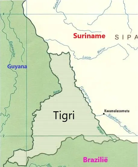
Discovery of the New River

Geologist Charles Barrington Brown discovers a significantly larger river west of the Kutari. According to the principle of the 'true source', this makes the Tigri area legally Surinamese.
Significance: Under international law, the river with the largest volume is considered the 'true source'. The New River is wider and demonstrably carries more water than the Kutari.
1900

British Rejection of the True Source

Lord Salisbury states that 'international convenience' outweighs geographical reality. Great Britain refuses to recognize the mistake of 1840 and relies on the long-term acceptance of the Kutari.
Significance: 'International convenience' has no basis in international law. The British position was never ratified by a binding treaty and cannot bind Suriname.
1936–1939

The Mixed Boundary Commission

A draft treaty: Suriname would cede the Tigri Triangle for sovereignty over the width of the Courantyne (Point 61). Never ratified due to WWII — legally invalid.
Significance: Suriname never formally ceded the Tigri Triangle. An unratified treaty creates no rights or obligations under international law.
1965

Renaming to Upper Courantyne

Prime Minister Pengel officially renames the 'New River' to the Upper Courantyne — a constitutional signal that Suriname rejects the British name and uses the principle 'Nature determines the source'.
Significance: By the official renaming, Suriname implicitly recognizes that the Schomburgk Line has no legal value. A strong state signal towards international law.
1968

Establishment of DEFPOL

Suriname establishes the Defense Police (DEFPOL) under Major Lapré. Observation posts — including Camp Tigri — are built to physically maintain sovereignty.
Significance: Effective exercise of sovereignty requires physical presence. DEFPOL established that presence in the Tigri area — an essential element under international law.
Aug 19, 1969

Operation Climax

The Guyana Defence Force attacks Camp Tigri. Surinamese troops are driven out. Guyana has occupied the area militarily ever since and renamed the base 'Camp Jaguar'.
Significance: Guyana's claim to 'prescription' requires 50+ years of uninterrupted peaceful occupation. A surprise attack on a sovereign camp explicitly does not qualify.
1970

Protocol of Chaguaramas

Suriname and Guyana agree to demilitarization pending a final solution. Suriname withdraws, but has protested for decades that Guyana is violating the treaty.
Significance: The Protocol implicitly recognizes Suriname's sovereignty: an occupying power does not negotiate over demilitarization of what it considers its own territory.
1975

Independence & Uti Possidetis Juris

Prime Minister Den Uyl confirms in writing that Tigri explicitly belongs to Suriname. Via 'uti possidetis juris' — colonial borders remain at independence — the claim is rock solid.
Significance: Den Uyl's written confirmation functions as an official constitutional document. Uti possidetis juris is binding international customary law, recognized by the ICJ.
2007

UN Maritime Tribunal (PCA Award)

An international tribunal settles the maritime border conflict. It accepts 'Point 61' from 1936 — which implicitly confirms that the entire width of the Courantyne to the western bank is Surinamese.
Significance: The acceptance of Point 61 is the most recent international recognition of Suriname's position on the Courantyne. The tribunal implicitly agreed with Suriname.
Late 2024

Infrastructure & Diplomatic Protest

President Irfaan Ali announces paving of the airstrip at Camp Jaguar. Minister Ramdin hands a heavy protest note to the Guyanese ambassador.
Significance: Infrastructural works on occupied territory violate the Protocol of Chaguaramas. Suriname's protest note is legally necessary to prevent 'acquiescence' — tacit agreement.

Our Stance:

"There is no 'disputed area'. There is only Surinamese territory currently being illegally occupied. Any map that omits the Tigri triangle is factually incorrect and harmful to national sovereignty."

Consulted Sources & Documentation

1799 Treaty (Amical Arrangement)

The fundamental agreement between the governors of Suriname and Berbice, analyzed in the PCA Arbitral Award (2007).

1936 Protocol (Draft Treaty)

The never-ratified protocol between the Netherlands and Great Britain. Source: Permanent Court of Arbitration Case 2004-02.

Dr. J.H. Adhin (1968)

'The Borders of Suriname' - The most authoritative legal analysis in Vox Guyanae. Leiden University (UBL).

BIBIS Suriname (2024 Protest Note)

Official protest note from the Ministry of BIBIS against illegal infrastructure at Camp Jaguar.