Scalable SVG files
Use the map at any size without losing quality. Ideal for websites, print, presentations and large displays.
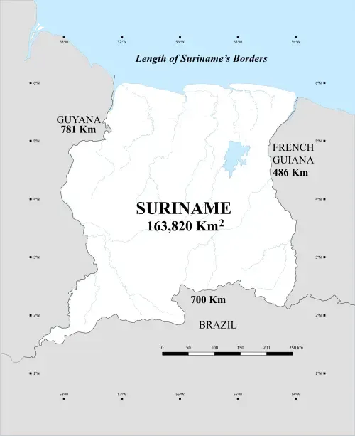
Download the correct, complete map of the Republic of Suriname, including the Tigri area. Available as a scalable SVG and in high resolution for designers, media, education and professional use.
Download scalable SVG, EPS, PNG and PDF files of Suriname, including the Tigri area. Made for designers, editors, education and organizations that need a sharp, editable and correct map.
Use the map at any size without losing quality. Ideal for websites, print, presentations and large displays.
Open the files in tools such as Figma, Illustrator, Inkscape, Canva or PowerPoint and easily adjust colors, lines and labels.
Suriname is shown including the Tigri area, with attention to historical, legal and cartographic completeness.
Downloads
Use the map directly in design software, presentations, print or online publications without redrawing it yourself.
The Tigri area is part of Suriname's historical and legal border position. That is why our maps show Suriname completely, including the disputed western area.
View the Tigri timelineFrom the Treaty of Breda and the Amical Arrangement to modern diplomatic protests: history explains why correct cartography matters.
Go to historyDownload directly or read why a complete map matters for education, media and professional design.